Introduction to Aerial Surveillance Using Satellite Images
Satellite imagery and aerial observation technologies have become important tools for understanding changes across the Earth's surface. They provide valuable information about forests, agricultural regions, urban development, water bodies, and environmental conditions. With the growth of Artificial Intelligence and Machine Learning, satellite images can now be analysed automatically to identify patterns and classify different geographical features.
Aerial Surveillance Using Satellite Images Using Machine Learning is an academic project that explores how machine learning algorithms and image processing techniques can be applied to satellite imagery. The system analyses aerial images to identify geographical objects, classify land cover, and observe changes across different locations and time periods.
Machine learning models can be trained using labelled satellite image datasets to recognise patterns associated with buildings, vegetation, roads, water bodies, and other land features. Computer vision techniques can also support image segmentation and geographical feature extraction.
This project is suitable for BCA final-year students interested in Artificial Intelligence, Machine Learning, Python Programming, Computer Vision, Remote Sensing, and Geospatial Technology.
Key Features & Benefits
Working Principle of the Satellite Image Analysis System
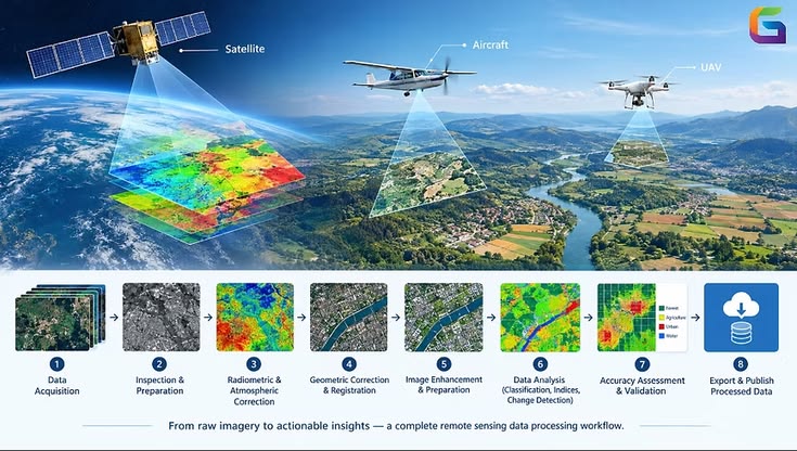
The proposed system follows a satellite image acquisition, preprocessing, and machine learning classification workflow.
The implementation can be divided into the following stages:
1. Satellite Image Collection: Collect satellite images from suitable public remote sensing datasets or authorised satellite imagery sources.
2. Image Preprocessing: Resize images, normalize pixel values, remove unwanted noise, and prepare the images for analysis.
3. Image Enhancement: Apply contrast enhancement and image correction techniques to improve visual quality where required.
4. Feature Extraction: Extract relevant geographical and visual features such as texture, colour information, vegetation patterns, and structural characteristics.
5. Machine Learning Model Training: Train a classification model using labelled satellite image samples.
6. Image Classification: Classify geographical regions into predefined categories such as vegetation, water bodies, urban areas, and agricultural land.
7. Change Detection: Compare satellite images captured at different times to identify changes in land cover and environmental conditions.
8. Result Visualization: Display classified images, geographical categories, and comparison results through an interactive dashboard.
Depending on project requirements, students can use traditional machine learning algorithms or advanced deep learning architectures for satellite image classification.
Implementation Guide
Technologies and Tools Used
The project combines programming, image processing, machine learning, and geospatial technologies.
Programming Language: Python is used for dataset preparation, image processing, model development, and classification.
Machine Learning: Scikit-learn provides algorithms such as Random Forest, Support Vector Machine, and Decision Tree for image classification experiments.
Deep Learning: TensorFlow, Keras, or PyTorch can be used to develop CNN-based satellite image classification models.
Image Processing: OpenCV and Pillow support image loading, resizing, enhancement, and processing.
Geospatial Libraries:
Rasterio for reading and processing raster satellite data.
GDAL for geospatial data operations.
GeoPandas for geographical vector data analysis.
NumPy for numerical image processing.
Data Analysis: Pandas and Matplotlib can be used for dataset analysis and result visualization.
Frontend Development: HTML, CSS, JavaScript, React.js, or Streamlit can provide an interactive user interface.
Backend Development: Flask or FastAPI can connect the trained machine learning model with the web application.
Database: MySQL or MongoDB can optionally store image information, classification results, and analysis history.
Students can select the technologies according to the available satellite dataset, image resolution, and computing resources.
Technical Specifications
Key Features and Real-World Applications
A machine learning-based satellite image analysis system can provide several useful features.
Satellite Image Upload: Allow users to upload supported satellite images for analysis.
Automatic Image Classification: Identify different geographical categories using trained machine learning models.
Land Cover Identification: Classify areas into vegetation, water bodies, agricultural regions, and urban landscapes.
Environmental Monitoring: Analyse geographical images to observe environmental changes.
Change Detection: Compare historical and recent satellite images to identify changes in land cover.
Image Segmentation: Divide satellite images into meaningful regions for more detailed geographical analysis.
Interactive Visualization: Display classification outputs and geographical information through an application dashboard.
Historical Analysis: Store previous analysis results to support comparisons across different observation periods.
Possible Applications
Forest cover monitoring.
Agricultural land observation.
Urban development analysis.
Water body monitoring.
Environmental change assessment.
Disaster impact assessment.
Land use and land cover classification.
Remote sensing research and education.
These applications demonstrate how satellite imagery and machine learning can support environmental research and geographical information analysis.
Conclusion & Next Steps
Advantages, Future Enhancements and Conclusion
Aerial Surveillance Using Satellite Images Using Machine Learning is a practical BCA final-year project that combines Artificial Intelligence, remote sensing, and computer vision.
One of its major advantages is the ability to analyse large geographical images using automated classification techniques. Machine learning models can identify visual patterns that help researchers understand land cover characteristics and monitor changes across different observation periods.
The project provides students with practical knowledge of Python programming, satellite image processing, machine learning algorithms, geospatial data handling, and application development.
Future Enhancements
The project can be improved through several advanced technologies:
Integration of CNN and Vision Transformer architectures for satellite image classification.
Use of Sentinel-2 and Landsat datasets for environmental analysis.
Automated forest cover change detection.
Vegetation analysis using NDVI (Normalized Difference Vegetation Index).
Integration of GIS mapping and geographical visualization.
Cloud-based satellite image processing.
Time-series analysis for monitoring long-term geographical changes.
Development of a web-based geospatial monitoring dashboard.
For reliable results, students should use appropriately labelled datasets, account for differences in image resolution and acquisition dates, and evaluate models using independent test images. Cloud cover, seasonal changes, and geographical variations can influence classification accuracy.
Conclusion
Aerial Surveillance Using Satellite Images Using Machine Learning is an interesting BCA final-year project that demonstrates how Artificial Intelligence and remote sensing can be combined for geographical image analysis. By integrating satellite image preprocessing, feature extraction, machine learning classification, and visualization techniques, students can develop an application for studying land cover and environmental changes.
The project provides a strong foundation for advanced research in satellite image processing, geospatial intelligence, and AI-based environmental monitoring.
Build Your AI and Machine Learning Project with Aislyn Technologies
Aislyn Technologies, Bangalore, provides project development guidance and technical support for students interested in BCA, Artificial Intelligence, Machine Learning, Python, Computer Vision, and Geospatial Technology.
Contact Details
Aislyn Technologies, Bangalore
Phone: +91 97395 94609
Email: info@aislyntech.com
Website: https://aislyn.in
Contact us today to start building your BCA final-year project in Artificial Intelligence and Machine Learning with our expert support!